Is GLONASS the new GPS?
Friday, 14 September, 2012
At the end of last year, the Russian government announced that GLONASS, the Russian global navigation satellite system, is fully operational and has global coverage. The team at Telit decided to test what impact this has on satellite navigation and positioning and how it compares to the US Global Positioning System (GPS).
Radio-based global navigation satellite systems are part of our daily life for navigation, surveying and mapping. Since October 2011, the Russian GLONASS has been fully operational with 24 satellites in orbit plus four in reserve and one currently undergoing trials. This is not only an alternative to GPS but, even more, the completion of a combined GPS/GLONASS system where there are, in total, 55 fully operational satellites in outer space in different orbits (see picture 1).
For satellite navigation, at least four satellites are needed to determine a position solution: three to provide the data for each space axis (x, y and z) and one to provide the time sent. The more satellites that can be tracked, the more accurate the fix will be.
In theory, this is possible with GPS-only as there should always be at least five satellites visible anywhere on the Earth’s surface. If there is an unobstructed view of the sky, even 12 satellites can be visible. But often there are buildings, trees, mountains or clouds blocking some of the GPS signals and the GPS receiver is unable to obtain a position fix.

Restrictions of GPS-only
Especially in cities with many skyscrapers, satellite signals are often lost. For fleet management as well as for other types of tracking applications this condition can be unacceptable. In addition, there are further restrictions of GPS-only navigation: GPS satellites orbit the earth from a distance of 20,000 km. Their signals are barely -130 dBm once they reach a terrestrial receiver and are degraded even further in urban environments. This makes it a real challenge to isolate them from background noise.
To overcome these limitations, the engineers at Telit decided to launch a combined solution of GPS and GLONASS. They believed the fact that there are now in total 55 satellites operating in different orbits covering the whole globe, it must have an impact on navigation and should provide advantages.
Combining GPS+GLONASS
The engineers decided to run a field test comparing the navigation accuracy of GPS-only receivers and GPS+GLONASS receivers. The team did seven test tracks between 11 am and 3 pm in downtown Los Angeles.
They tested several standard GPS-only units in comparison to the Jupiter SL869, Telit’s GNSS module which processes both GPS and GLONASS signals.
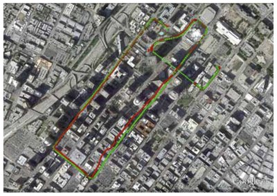
The results were always very similar - combining GPS and GLONASS provided much more accurate and better positioning possibilities instead of GPS-only (see picture 2).
The picture shows a single test track. The red line represents GPS-only. It shows that during the test track there were several instances where GPS was not able to determine a position solution. With a GPS+GLONASS receiver this didn’t happen - the receiver never lost the signal.
Furthermore, there is a huge difference in the accuracy of ground track. With GPS there were several metres tracked off-road, which means the track was not on the street but next to it. With GPS+GLONASS the positioning was very accurate and it didn’t happen at all.

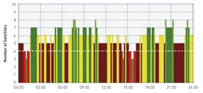
A similar study was conducted in London monitoring the number of satellites used by a GPS-only receiver and by a GPS+GLONASS receiver. The findings were the same as in Los Angeles. Because of signal blockages in London caused by five-storey buildings, the number of tracked GPS satellites dropped below four (picture 3). Thus, the GPS-only receiver lost its fix point.

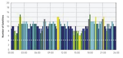
This happened three times, of which the time around 3 pm was the most critical one. At that time the receiver had no track for about 20 minutes. The same test tracking was done with GPS+GLONASS. It showed that there are always more than four satellites in track. A fix is virtually guaranteed (picture 4). In addition, even up to 15 satellites were tracked in the middle of London where it wasn’t possible to track more than eight satellites with GPS-only. That nearly doubled the available satellites.

Central findings of the tests
The tests showed that due to the addition of GLONASS, the number of tracked satellites never drops below six, and the problem of lost satellite coverage, especially problematic in urban canyons with tall buildings, is dramatically reduced.
Furthermore, the test showed that the accuracy of positioning is significant improved. In addition, the team noticed an improved time-to-fix, which is, for example, vital for stolen vehicle recovery where it is crucial to locate the vehicle no matter where it is.
Accessing the combined GPS/GLONASS constellations is thus a major step forward in navigation, providing the best satellite geometry to obtain the most accurate position possible more often - not only in Russia but all over the world. Finally, this enables a more accurate positioning, a better ‘pinning’ of a person, a car or an asset’s true location on a digital map.
Further tests are underway in South Africa and it is expected that the findings so far will be confirmed there.
Glyn High-Tech Distribution is the distributor for Telit products in Australia and New Zealand.
GNSS technique helps pedestrians navigate 'urban canyons'
The technique addresses the shortcomings of traditional GNSS systems in complex urban landscapes...
LEO and UWB hold the key to interference-free navigation
While advanced positioning technologies are crucial for overcoming challenges in navigation, many...
Ericsson provides 5G for high-stakes race
Ericsson has come on board as a team partner for the ultrahigh-tech catamaran race SailGP,...


